Snakes and Ladders

posted in: 2016 | 2


Snakes and Ladders – A climber’s tale (July 2016)

The original plan this weekend was to continue working our way through the 100 classic climbs of North Wales; however, Mother Nature had other plans for us. As the rain bucketed we decided to revert to plan B – we were about to embark on an epic slate adventure, known as the infamous snakes and ladders (and tunnels).


Dali’s hole and California

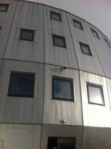
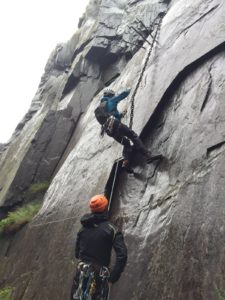
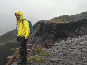
It was about eleven o clock before the four of us rocked up at Bus Stop quarry; head to toe in Goretex we set off into the slate quarries for the beginning of our slate odyssey. A short walk led us to our first landmark a surreal place named Dali’s hole – from here we navigate through a couple of tunnels and into California where we had our first glimpse of the long iron chain that hung from the tunnel above. A lengthy silence from all in the group suggested there were no immediate volunteers for the first lead, but then up steps Jack for the challenge. So without further ado, let battle commence…. 40 minutes later and all in one piece we complete the climb and stand at the entrance to the tunnel feeling pretty elated.

hanging onclimbing the chainTasmania and Australia

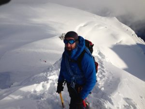
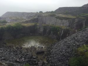
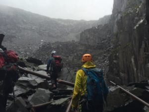
At the end of the tunnel we abseil from a birch tree down a soaked, slippery slate wall and begin the search in Tasmania for a concealed tunnel. With four pairs of eyes on the job we quickly discover it – remove our rucksacks – squeeze ourselves in and stumble our way through an obstacle course that is ankle deep in water. We arrive into Australia with a few bumps and bruises and are faced with two options to get us up to the next level, both of which look equally unappealing. Therefore, we unanimously decide to head right and scramble over the loose slate, which was interesting to say the least, especially as the rain persisted. Eventually we arrive at a grassy terrace area where we come across the first ladder, which is notably now seriously out of commission. A quick alternative scramble over shiny, wet slate boulders has us up on the next level and ready for the next ladder – half a dozen rusty iron ladders later see’s us at the top section of the slate mines, which contain a number of interesting old disused buildings. We stop here for a well-deserved brew and to take brief shelter from the rain.


Heading into Australia

The Lost World

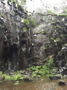
Next stop is to find the Lost World; admittedly this was quite a challenge and was a little time consuming. However, eventually we stumble across it and find the abseil point on the right hand side overlooked by the Dinorwig unconquerable E3, 5C. A couple of abseils, followed by a series of down climb ladders finds us at ground level of the Lost World jungle. Here we take a quick look around this amazing place and then it’s time to exit via another tunnel into the infamous Mordor.


great ladder of MordorMordor

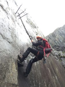
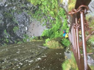
At this point in the day the two paper guides I had brought along for directions were no longer legible, as the endless torrent of rain had resulted in them forming into paper Mache in my pocket. As a result, we mistakenly decide to down climb the three ladders of Mordor and wander knee deep in water through the only tunnel for approximately a quarter of a mile… until we reach a dead end! After several attempts of trying to squeeze through, we agree this is not the way out. We begin to feel a little claustrophobic, but then the mood is quickly lightened by Dave suggesting that, “perhaps next time we should laminate the guide”! It was then, as we stood in the cold, wet, darkness we remember that when we first entered Mordor (which seemed like hours ago) there was another ladder heading up. So without further ado we make a hasty retreat back out of the tunnel, by now our feet and socks soaked, and climb the three ladders to the entrance level. We then skirt the quarry and climb the great ladder, taking care not to fall to the depths below.


Khyber Pass

At this stage, the general consensus is to get out of the rain and head to the sanctuary of Pete’s Eats, a few minor details such as the perilous steps from one incomplete wobbly ladder to another is not going to hinder us. As we reach the top of the last ladder, or so we think, there’s another ancient, slippery, rusty iron ladder waiting to be climbed; finally we emerge at the Khyber Pass. From here we take a short walk to the collapsed ‘bridge of death’ – skirt around the re-entrant to the other side on some loose slate – stop to snap a few photos and contemplate the journey, whilst all secretly feeling quite pleased that the ‘bridge of death’ had collapsed as I don’t think any of us was up for that one.


bridge of death no more


By now the homing pigeon in us had taken over and we quickly scramble over some scree – hop over a couple of fences – walk down an old railway track and back onto the safety of the footpath with the next challenge in mind. Do I go for Big Jim’s or the Monster omelette and chips????

Cheers to Dave, Giles and Jack for joining me on this epic adventure, I’m sure we’ll be back one day in the dry….


Winter in the High Atlas Mountains

posted in: 2016 | 0

Marrakech, Imlil and beyond

We set aside one night to experience the hustle & bustle of Jema el-Fnaa, the main square and souk marketplace in Marrakesh‘s medina quarter (old city). The place transforms at dusk,  people come out for an early evening promenade and the square gradually fills until it becomes a whole carnival of storytellers, acrobats, musicians and entertainers.The following day we he
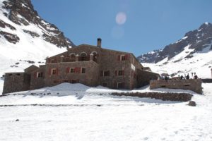
ad 50 miles south, away from the mayhem to Imlil a small Berber village on the outskirts of the high Atlas Mountains. At 1740 metres above sea level it is the starting point for most people heading up into the high atlas for trekking. The Atlas mountain range is special in that it is a natural barrier between the Mediterranean and Atlantic coastlines and a buffer to the Sahara Desert. The mountains extend almost 2400 kilometers through Morocco, Algeria and Tunisia.

From Imlil it’s a steady 6 hr trek to the huts with about 1500m of ascent. Passing through Aroumd (rugs) and the half way point of Sidi Chamharouch, where the snow line begins, here we have to negotiate over the mule/porter ?!, the path then leads over the stream and runs steeply uphill to the right side of the Isougouane valley and becomes a trudging snow plod. It’s certainly possible to do this with no support if you have a large rucksack and no other luggage. However, bear in mind the ascent and altitude and you may decide to use the excuse of “supporting the local economy” and take a mule. We chucked our kit in large duffel bags to include ice climbing and extreme weather gear & some food in addition to normal winter mountaineering stuff. Note :mules don’t go above the snowline. So make sure you arrange a porter bend otherwise you will have to struggle with your own bags and rucksacks…

Les Mouflons hut & Base camp 3207 metres

The private Les Mouflons hut has no heating at all but they have a roaring log fire going in the main room and do some great carb loaded meals in the evening and simple breakfast. We stay here for the next four nights and although it is below freezing in the dorm we like it. You need a good, warm sleeping bag for the hut & spare clothing and and ice scraper for the window in the morning, so factor this in when deciding for or against the use of a four legged friend to carry your gear…

At the end of each day there’s time to relax, dry your wet stuff in front of the fire and practice speaking a multitude of languages as per the other trekkers staying at the refuge, before dinner at around 7pm. As early starts are the norm in most mountain huts, early nights are advisable, however there is a fire in the communal area and some guests do stay there until late especially if they have already summited and are heading back to Marrakech.


Jebel Toubkal (4167m)  

The highest and most climbed peak in North Africa, we plan to climb it via the North cwm north col route to experience the mountain at its best and hopefully to ourselves, so an early start was required in order to get back down before the deep snow started melting making it a tiring slog. Conditions were cold, but perfect, with the snow having a hard crust on the walk down the valley, very quickly the ground steepens and it’s a bit of a drag up to the cwm, we are looking out for an aircraft wreckage but there is no sign of it with the deep snow covering, so we head for a prominent broad gully at the back of the cwm, It’s a straight forward Grade 1 gulley but the effects of altitude make for slow progress, at the top we hit the ridge line and turn right and a steepening scramble leads us towards the summit plateau and the first glimpse of the summit Triangle after 5/12 hrs. We have the summit to ourselves, photos done, views admired it’s time for the descent, we take the South cwm south col route via Tizi n Toubkal, it’s a steady route and it’s the first time we come across other people all day, we arrive back at the hut after about 8 hrs.


Ice climbing in the Sun !

We dedicated ourselves a full day for this in between the two 4000 metre mountaineering days, the objective today was to walk the shortest distance to get the most ice climbing done, both of which were satisfied. We found a gorge with a frozen waterfall a short walk south from the hut and abseiled in to the base of the climbs; we set up a few different climbs and spent an amazing day ice climbing in the warm sun.

Akioud (4030m) (via Tizi Afella)

The plan today was to head further south than we ventured yesterday into Amrharas n-Iglioua and take the North north-west ridge (PD+) to the summit. At least that was the plan anyway until we decided to take a diversion due to the snow being soft as the sun was already out in full force, this resulted in us heading for the shade where the firmer snow was and as a result we arrived at Tizi Afella. This was not recommended in the guidebook as it necessitates an awkward descent, traverse and re-ascent back up to the NNW ridge! The snow condition looked good so we took the challenge, ice axes gripped firmly in hand, we were not disappointed, some great exposure on the traverse with steep slopes falling away to our right, leading us onto the final ridge line to scramble to reach the summit. Once again we sat at the summit on our own watching the ant like people on the busy neighbouring summits of Ras and Timesguida.

Mont Blanc – The Roof Top to Europe

posted in: 2016 | 0

North Wales rock and snow

The idea to climb Mont Blanc came about after Dave and I met up one evening in Ye Old Murrenger House in my home town of Newport. Having lost touch and not climbed together in over fifteen years it was a quick decision. After reminiscing over a few beers, we came up with a plan, which was agreed to take place in seven months. Prior to this, Dave would head north to Snowdonia most weekends, in which we would scramble and climb together on some of the famous classic rock routes in North Wales, to gain the necessary alpine skills. We planned the route and necessary acclimatisation stages to give us the best chance of summiting and booked the mountain refuges before we left for Chamonix, our base for the trip.

Italy and back again…

We arrived at our chalet in Cham in the early hours of the morning due to a delay at the airport. Not the best start to the trip. After a few hours sleep, we are up, out and on our way into the town centre, heading to the Italian side of the Alps to acclimatise overnight. We take the early morning cable car from Chamonix town centre up to the Aiguille du Midi top station at 3842 metres, the thermometer at the top station registers minus nineteen degrees Celsius; it’s bitterly cold with the additional wind chill as we exit the cable car. Twenty minutes later we walk out through the ice tunnel, roped together, passing the photographers into a glorious sunshine filled blue sky and exit through the gate onto the magnificent snow arête, which makes up the Midi East ridge.

Ice axe gripped and crampons fitted we head slowly down the exposed ridge – the Crib Goch traverse we did back in North Wales in full winter conditions is no match for this. From here it’s approximately five hours of walking across the glacial valley (Valle Blanche) towards Italy avoiding the crevasses and passing under seracs. This is easier said than done, as we both have our moments stumbling waist deep into small crevasses.

When we eventually arrive at the Refuge Torino, sunburned and dehydrated we are told there is no reservation! but can stay at the old refuge, this means descending a further 228 steps. The accommodation at the hut is fine, but we have a disturbed night’s sleep due to thunderstorms and the effects of altitude at 3375 metres (1.2kms directly above the MB tunnel). The following morning we ascend the 228 steps for the fourth and final time and head north back towards France and our start point from yesterday, the views are spectacular, but the snow is deeper following last night’s storm and the going is tough. We get back to the snow arête just gone midday and the sun is feeling warm on our backs and the snow is starting to melt, not the best conditions for our ascent. As we start the climb back up we can hear a woman screaming on the descent, obviously not enjoying here first experience on the snow arête; we stand to one side as she passes with her guide holding her tightly on the rope. We head back up & take the cable back down to Cham where we spend the night at a low level of 1000 metres.

On Route to the Refuge de Tete Rousse

The following morning we head out early again, grabbing some freshly baked croissants from our chalet and take the free bus service to Les Houches, and then cable car to Bellevue Station. From here we take the Tramway du Mont Blanc up to the Nid d’Aigle (the eagle’s nest) at 2372 metres, we then head south on foot and pick up a rough rocky path, up the ridge of the Aiguille du Gouter. We pass mountaineers coming back down who have not summited due to bad weather conditions. As the rocky ridge line separating the Griaz and Tete Rousse Glaciers gains height the scenery just gets better and better. After a few hours of scrambling the refuge comes into sight, including several tents that are pitched nearby – we briefly stop to put crampons on to cross the glacier, we are now above the snowline and head in for the night at 3167 metres. Up above in the distance we can just make out the silhouette of the Gouter hut perched high on the cliffs.

Next stop Gouter Hut

The following morning we take a leisurely breakfast whilst we watch the snow storm conditions outside. We weren’t going anywhere until it eases… Four hours later after a conversation with the hut guardian and a phone call to the Gouter hut to ensure there are still beds available for us, we’re off again and heading through the snow, which continues to fall. We scramble up the ridge towards the Grand Couloir and arrive to find a Swiss guide with two clients negotiating their way across. A quick assessment of the amount of snow above suggests that the rock-fall should be minimal so we clip into the metal wire and head across quickly – we don’t stop to Pass Go or collect £200, just unclip, take in coils and continue scrambling up the south side of the ridge to the Aiguille du Gouter. As we gain height the snow underfoot turns to ice, so as a safety precaution we clip into the pre-installed cables, which leads us to the old Gouter hut. The view from here is fantastic, or so we have been told… As we are not blessed with an opportunity for photos today, so push on up a short snow slope to a flattening and then a few minutes later the impressive design of the Gouter hut comes into view at 3815 metres. It looks like it’s bolted to the side of the cliff and should be in a Bond film, the first question that springs to mind: How the f..k did they build that up here ?!


The Waiting Game

When we finally remove our outdoor gear and enter the hut we’re given a warm welcome by the handful of mountaineers already there, we get ourselves squared away in our dorm and head back for an evening meal of soup & pasta. At this point the hut guardian hits us with the bad news that the summit is out of the question tomorrow due to further snow and thunderstorms. So, we just have to wait and pass time by playing cards and working our way through the library of mountaineering literature left behind by previous climbers. The snow storms still do not ease and we are now concerned that we may not have enough time to go on any further and may have to go back down. Eventually twenty four hours later the guardian announces “breakfast will be served at 2 am”. A joyful cheer erupts, the waiting game is over, the summit is game on! The atmosphere in the hut immediately changes to one of excitement, and then urgency, as people begin organising and packing their kit ready for the off.

Monte Bianco (4807m)

It’s nearly half one in the morning when the first person in our dorm starts getting dressed by torch light, clearly trying to be quiet but not succeeding – I’ve not slept a wink due to altitude – within minutes the whole dorm is up and rushing to get ready. We grab something quick for breakfast and kit up in the outer building. It’s a clear night sky, with good visibility and temperatures are below minus twenty as we move out into the darkness up towards the Dome du Gouter.

We soon warm up on the steep slopes as we commence a slow but steady pace, the snow is deep from the recent snow storms making it leg sapping work. As we gain height the wind chill kicks in dropping the temperature further, it’s bitterly cold and my hands are freezing as I only have liners on but we decide not to stop until we reach the emergency Vallot hut. We enter the hut after climbing up a steep snow slope about two and a half hours later, the temperature is minus thirty something, my hands are so cold I struggle to add extra layers and over gloves. Dave helps and then attempts to drink from his water bottle but its frozen solid, my hot drink satisfies our requirements instead. A quick protein bar down the hatch and it’s time to get back outside and head up the exposed snow ridge for the summit. It’s still a tough long slog, in which we are battered constantly by the near gale force winds on the infamous Boissons ridge. At one point we stop and contemplate turning back, thankfully, the dawn sun makes its appearance and immediately the sun has a warming effect making it bearable again. We continue to push on up the exposed ridge to eventually arrive at the summit approximately three and a half hours later. We’re behind our scheduled time so have to cut short our summit celebrations and settle for a hand shake. As we stand on the roof top to Europe and take in the view, reality kicks in, we’re only half way and we have to get back down to the valley before the last tram leaves, as we fly home first thing tomorrow.

It’s all downhill from here

The next few hours involve us moving downhill at a rapid rate of knots, its warmer now as the sun is high above. We pass the Vallot hut and continue towards the Gouter, passing other mountaineers heading up towards the summit, no time to stop we have a train to catch. As we approach the old hut I catch one of my crampons on my goretex trousers sending me flying, face first down a snow slope, I make good use of my ice axe to brake my fall and I lie there laughing hysterically. I struggle to my feet, my legs are feeling heavy now, we’ve been going for about ten hours, it’s a perfect opportunity to remove layers and eat before continuing our descent towards the grand couloir. The ridge is still icy so we clip to the steel ropes and continue downwards carefully heading towards the grand couloir, when we arrive its almost midday and the risk from rockfall is much higher than on the way up as the snow above is already melting. We decide to leg it across this time and do not bother clipping to the cable, this proves to be a good choice as we shave minutes off the return crossing. On the other side the descent it’s mostly rock and scree scrambling so we remove crampons and push on until we arrive at the Tete Rousse. We’ve made good time, from here it’s about another  two hours to the tramway, we should make it before the last tram departs…..